Quick Navigation:
| | |
DRAINAGE
Introduction to Drainage
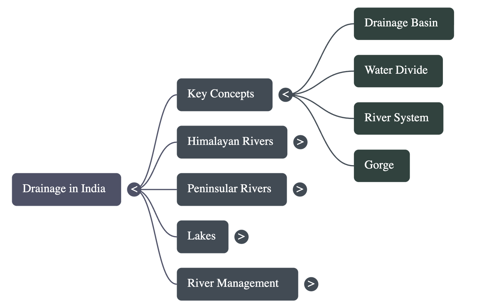
- Drainage: The term describes the river system of an area.
- Drainage Basin: The specific area drained by a single river system.
- Water Divide: An elevated area, such as a mountain or an upland, that separates two drainage basins (e.g., Ambala is located on the water divide between the Indus and the Ganga river systems).
Drainage Systems in India
Indian rivers are divided into two major groups based on the broad relief features of the subcontinent:
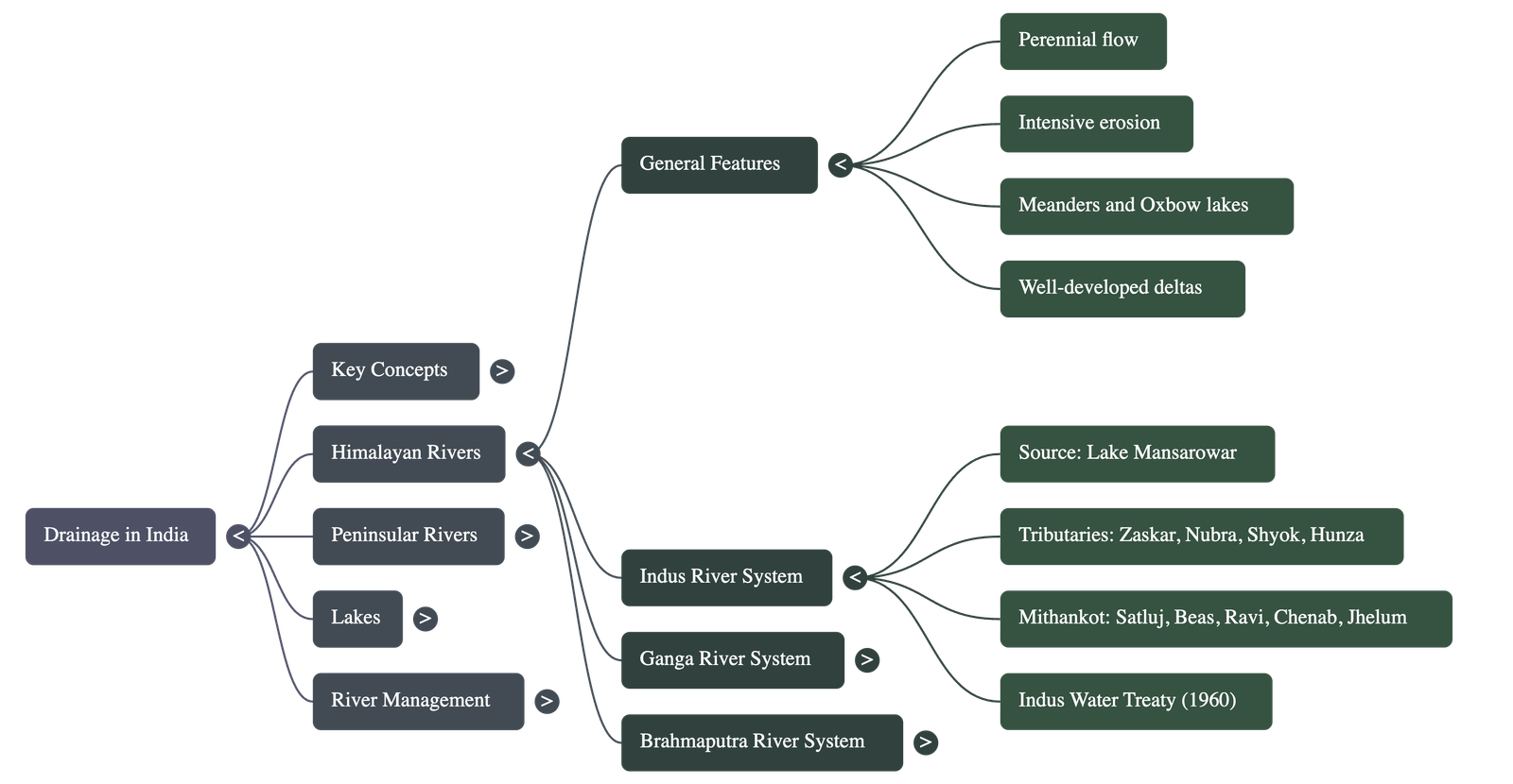
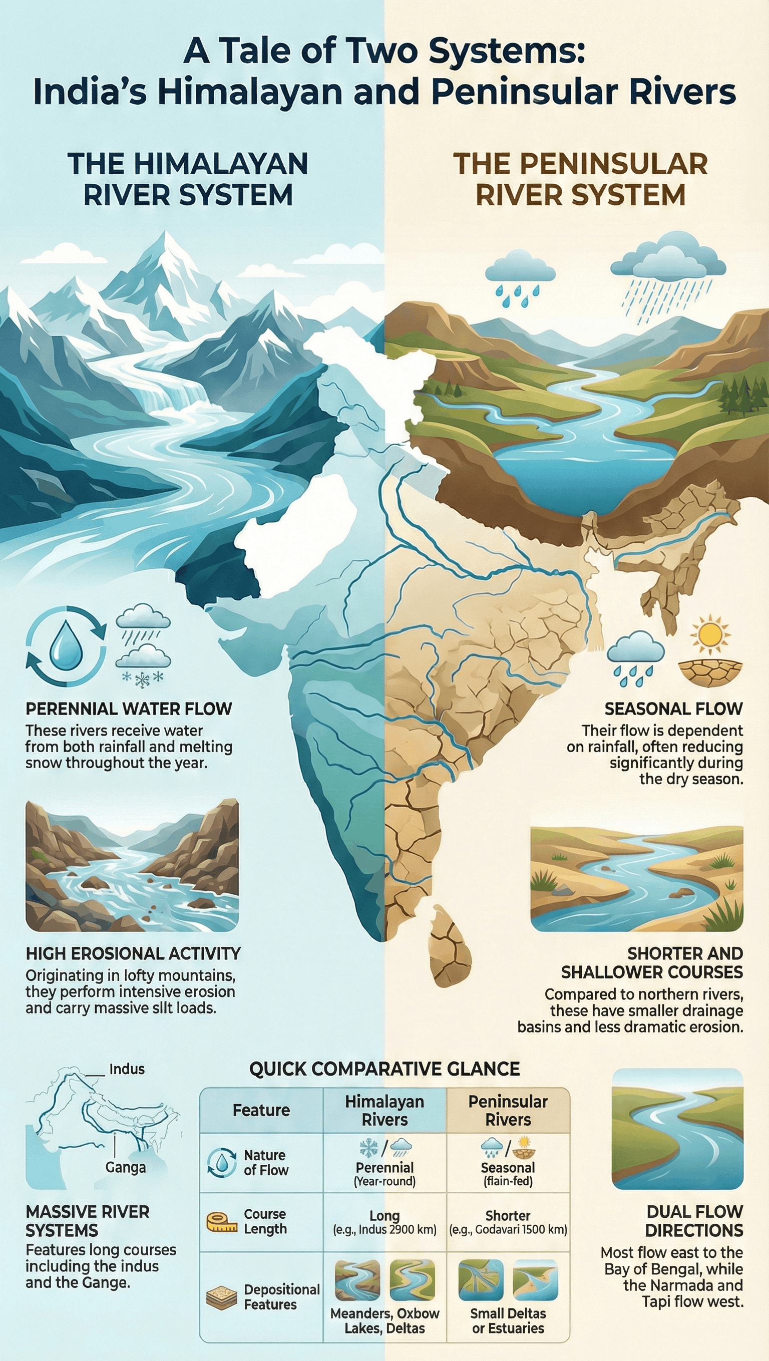
1. The Himalayan Rivers
- Perennial Nature: Most are perennial, meaning they have water throughout the year because they are fed by rain and melting snow.
- Long Courses: They have long courses from their source to the sea and perform intensive erosional activity in their upper courses, carrying huge loads of silt and sand.
- Depositional Features: In middle and lower courses, they form meanders, oxbow lakes, and well-developed deltas.
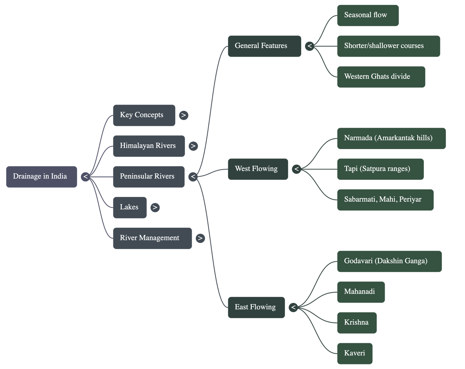
2. The Peninsular Rivers
- Seasonal Nature: Flow is dependent on rainfall; even large rivers have reduced flow during the dry season.
- Physical Characteristics: They have shorter and shallower courses compared to Himalayan rivers.
- Direction: Most originate in the Western Ghats and flow towards the Bay of Bengal, though some originate in the central highlands and flow west.
The Himalayan River Systems
The Indus River System
- Origin: Rises in Tibet, near Lake Mansarowar.
- Course: Enters India in Ladakh, flowing west. It is joined by tributaries like the Zaskar, Nubra, Shyok, and Hunza.
- Major Tributaries: The Satluj, Beas, Ravi, Chenab, and Jhelum join the Indus near Mithankot in Pakistan.
- Length: It is one of the longest rivers in the world, with a total length of 2900 km.
- Basin: Distributed between India (Ladakh, J&K, Himachal Pradesh, Punjab) and Pakistan.
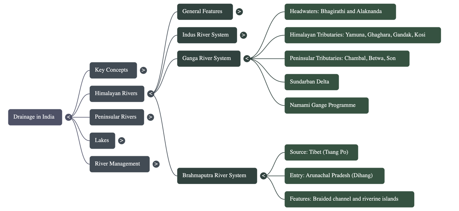
The Ganga River System
- Headwaters: The Bhagirathi (fed by Gangotri Glacier) joins the Alaknanda at Devaprayag to form the Ganga. It emerges onto the plains at Haridwar.
- Tributaries:
- Himalayan: Yamuna (flows parallel and joins at Allahabad), Ghaghara, Gandak, and Kosi.
- Peninsular: Chambal, Betwa, and Son (rising from semi-arid areas).
- Course: Flows eastwards to Farakka (West Bengal), where it bifurcates. The Bhagirathi-Hooghly flows south to the Bay of Bengal, while the mainstream enters Bangladesh and joins the Brahmaputra (becoming the Meghna).
- Delta: The Sundarban Delta is the world's largest and fastest-growing delta, home to the Royal Bengal tiger.
- Length: Over 2500 km.
The Brahmaputra River System
- Origin: Rises in Tibet east of Mansarowar lake (known as Tsang Po).
- Course: Flows east parallel to the Himalayas. It takes a U-turn at Namcha Barwa and enters India in Arunachal Pradesh through a gorge (known as Dihang).
- Characteristics:
- In Tibet, it carries little water and silt (cold/dry area).
- In India, it passes through a high rainfall region, carrying large volumes of water and silt.
- It forms a braided channel in Assam with many riverine islands (including the world's largest riverine island).
- It is prone to frequent shifting of channels and devastating floods.
The Peninsular River Systems
The Western Ghats act as the main water divide. Major rivers flow east into the Bay of Bengal and form deltas. Only the Narmada and Tapi flow west and form estuaries.
- The Narmada Basin: Rises in the Amarkantak hills (MP). Flows west in a rift valley. Famous features include the 'Marble rocks' near Jabalpur and 'Dhuadhar falls'.
- The Tapi Basin: Rises in the Satpura ranges (Betul district, MP). Flows in a rift valley parallel to the Narmada but is much shorter.
- The Godavari Basin: The largest Peninsular river (often called "Dakshin Ganga"). Rises in Nasik (Maharashtra) with a length of about 1500 km. Tributaries include Purna, Wardha, Pranhita, Manjra, Wainganga, and Penganga.
- The Mahanadi Basin: Rises in the highlands of Chhattisgarh. Length is about 860 km. Flows through Odisha to the Bay of Bengal.
- The Krishna Basin: Rises near Mahabaleshwar. Length is about 1400 km. Tributaries include Tungabhadra, Koyana, Ghatprabha, Musi, and Bhima.
- The Kaveri Basin: Rises in the Brahmagiri range (Western Ghats). Length is about 760 km. Famous for the Shivasamudram Falls (second biggest in India).
Lakes
Lakes vary in size and origin (permanent, seasonal, glacial, tectonic, or artificial).
- Formation Types:
- Ox-bow lakes: Formed by meandering rivers cutting off across floodplains.
- Lagoons: Formed by spits and bars in coastal areas (e.g., Chilika, Pulicat, Kolleru).
- Glacial lakes: Formed when glaciers dug out basins later filled with snowmelt (common in Himalayas).
- Tectonic lakes: Formed by tectonic activity (e.g., Wular Lake, the largest freshwater lake in India).
- Artificial lakes: Created by damming rivers (e.g., Guru Gobind Sagar).
- Salt Water Lakes: Examples include Sambhar Lake in Rajasthan, used for salt production.
- Importance: Regulate river flow, prevent flooding, aid in hydel power generation, moderate climate, maintain aquatic ecosystems, and support tourism.
Role of Rivers in the Economy & Pollution
Economic Significance
- Rivers have historically attracted settlers, leading to the growth of major cities.
- Water is a basic resource essential for irrigation, navigation, and hydro-power generation.
- Agriculture, the major livelihood in India, relies heavily on river water.
River Pollution
- Causes: Growing demand from domestic, municipal, industrial, and agricultural sectors reduces water volume. Untreated sewage and industrial effluents are dumped into rivers.
- Impact: Pollution affects water quality and the river's self-cleansing capacity. Urbanization and industrialization have increased pollution levels.
- Conservation Plans:
- Ganga Action Plan (GAP): Initiated in 1985.
- National River Conservation Plan (NRCP): Expanded in 1995 to improve water quality in major rivers through pollution abatement work.
Quick Navigation:
| | |
1 / 1
Quick Navigation:
| | |