Quick Navigation:
| | |
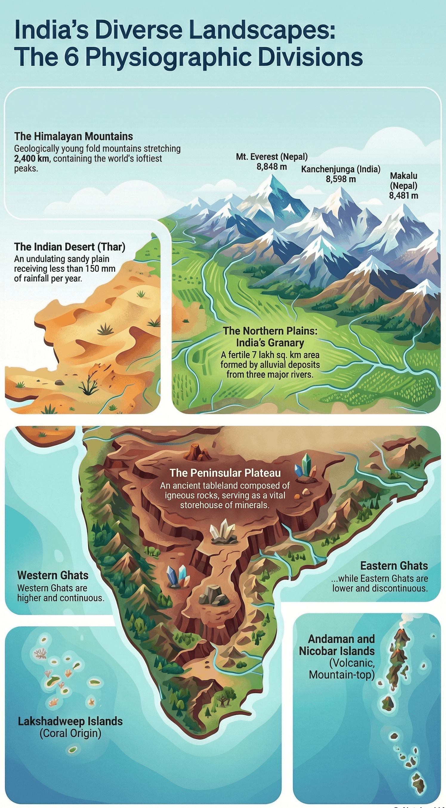
Physical Features of India
Introduction
- India is a vast country containing practically all major physical features of the earth: mountains, plains, deserts, plateaus, and islands.
- Geological Context:
- The Peninsular Plateau is one of the oldest and most stable landmasses on earth, composed of igneous and metamorphic rocks.
- The Himalayas and the Northern Plains are geologically recent landforms. The Himalayas form an unstable zone with youthful topography (high peaks, deep valleys, fast-flowing rivers).
- The Northern Plains are formed of alluvial deposits.
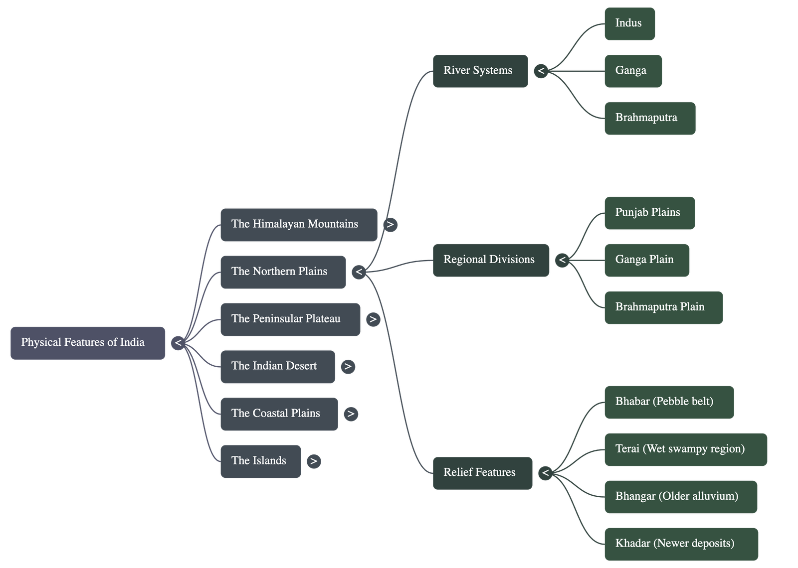
1. The Himalayan Mountains
The Himalayas are geologically young fold mountains stretching over India's northern borders.
- Extent: They run west-east from the Indus to the Brahmaputra, covering an arc of about 2,400 km.
- Width: Varies from 400 km in Kashmir to 150 km in Arunachal Pradesh.
- Three Parallel Ranges:
- The Great or Inner Himalayas (Himadri): The northernmost, most continuous range. Contains the loftiest peaks (average height 6,000 metres), including Mt. Everest and Kanchenjunga. The core is granite and perennially snowbound.
- The Himachal or Lesser Himalayas: South of the Himadri. Composed of compressed rocks. Altitude ranges from 3,700 to 4,500 metres. Includes famous ranges like Pir Panjal and Dhaula Dhar, and valleys like Kashmir, Kangra, and Kullu.
- The Shiwaliks: The outermost range. Width of 10-50 km, altitude 900-1100 metres. Composed of unconsolidated sediments. Longitudinal valleys between Lesser Himalayas and Shiwaliks are called Duns (e.g., Dehra Dun).
- Regional Divisions (West to East): Punjab Himalayas (Indus-Satluj), Kumaon Himalayas (Satluj-Kali), Nepal Himalayas (Kali-Teesta), and Assam Himalayas (Teesta-Dihang).
- The Purvachal: Eastern hills beyond the Dihang gorge. Composed of sedimentary sandstones and covered in dense forests (e.g., Patkai, Naga, Manipur, and Mizo hills).
2. The Northern Plain
Formed by the interplay of the Indus, the Ganga, and the Brahmaputra river systems.
- Characteristics: Formed of alluvial soil, densely populated, agriculturally very productive due to rich soil and adequate water.
- Dimensions: About 2400 km long and 240-320 km broad.
- Three Sections:
- Punjab Plains: Western part, formed by the Indus and its tributaries. Dominated by doabs.
- Ganga Plain: Extends between Ghaggar and Teesta rivers (North India).
- Brahmaputra Plain: Lies mainly in Assam.
- Relief Features:
- Bhabar: Narrow belt of pebbles deposited by rivers parallel to Shiwalik slopes; streams disappear here.
- Terai: Wet, swampy, marshy region south of Bhabar where streams re-emerge; historically forested.
- Bhangar: Older alluvium forming terrace-like features; contains calcareous deposits called kankar.
- Khadar: Newer, younger deposits of floodplains; fertile and renewed annually.
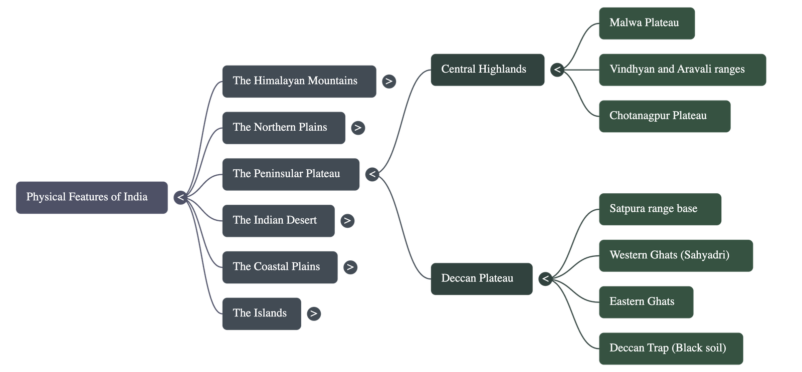
3. The Peninsular Plateau
A tableland composed of old crystalline, igneous, and metamorphic rocks; part of the ancient Gondwana land.
- Two Broad Divisions:
- Central Highlands: Lies north of the Narmada river (covering Malwa plateau). Bounded by Vindhyas (south) and Aravalis (northwest). Wider in the west, narrower in the east. Eastern extensions known as Bundelkhand and Baghelkhand.
- Deccan Plateau: Triangular landmass south of the Narmada. Flanked by Satpuras in the north. Separated from the Chotanagpur Plateau by a fault.
- Western Ghats vs. Eastern Ghats:
- Western Ghats: Higher (900-1600m), continuous (crossed only via passes), cause orographic rain. Highest peaks: Anai Mudi and Doda Betta.
- Eastern Ghats: Lower (600m), discontinuous, dissected by rivers draining into Bay of Bengal. Highest peak: Mahendragiri.
- Deccan Trap: A distinct feature of volcanic origin with black soil.
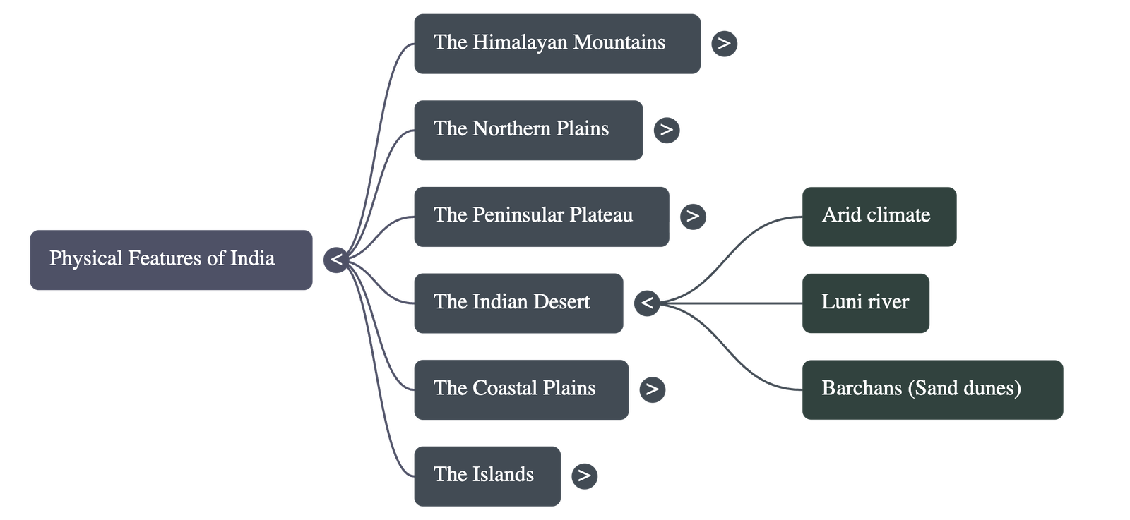
4. The Indian Desert
- Located towards the western margins of the Aravali Hills.
- Undulating sandy plain covered with sand dunes.
- Climate: Arid with very low rainfall (below 150 mm/year) and low vegetation cover.
- Features: Barchans (crescent-shaped dunes) are prominent. Luni is the only large river in this region.
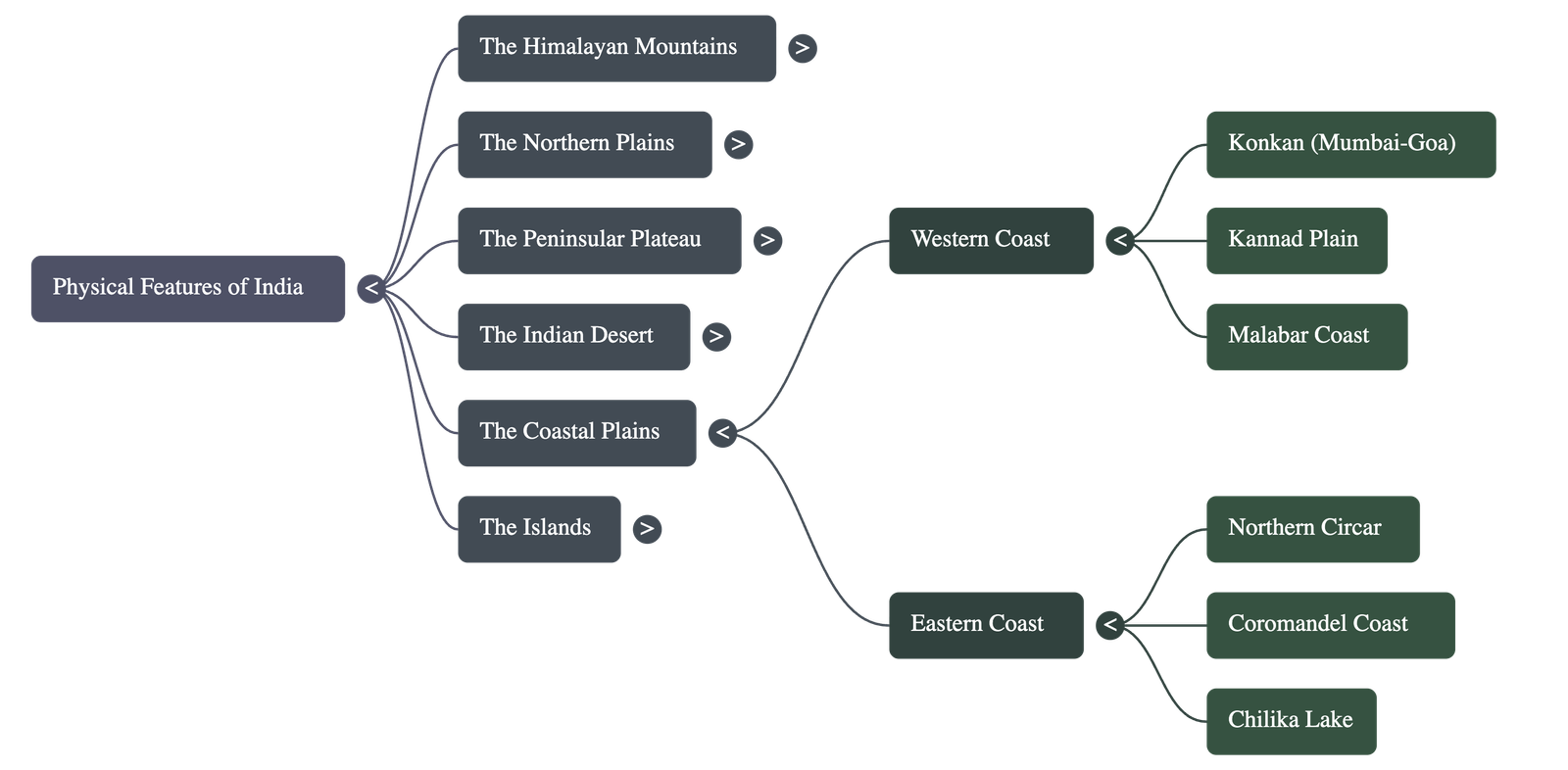
5. The Coastal Plains
Narrow coastal strips flanking the Peninsular plateau.
- Western Coast: Sandwiched between Western Ghats and Arabian Sea. It is a narrow plain divided into:
- Konkan: Northern part (Mumbai – Goa).
- Kannad Plain: Central stretch.
- Malabar Coast: Southern stretch.
- Eastern Coast: Along the Bay of Bengal. Wide and level. Divided into:
- Northern Circar: Northern part.
- Coromandel Coast: Southern part.
- Large rivers (Mahanadi, Godavari, Krishna, Kaveri) form extensive deltas here. Chilika Lake is an important feature.
6. The Islands
- Lakshadweep Islands:
- Located close to the Malabar coast of Kerala.
- Composed of small coral islands.
- Administrative headquarters: Kavaratti.
- Rich flora and fauna; Pitti island has a bird sanctuary.
- Andaman and Nicobar Islands:
- Elongated chain in the Bay of Bengal.
- Bigger in size, more numerous, and scattered.
- Believed to be elevated portions of submarine mountains.
- Strategic importance; possess active volcanoes (Barren Island) and equatorial climate with thick forests.
Conclusion: Each physiographic region complements the others, making the country rich in natural resources and future development possibilities.
Quick Navigation:
| | |
1 / 1
Quick Navigation:
| | |